Cenote Taj Mahal Cartography Project
Donation protected
Cenote Taj Mahal Cartography Project
The Taj Mahal cave system :
The state of Quintana Roo in Mexico is a paradise for cave diving, more than 1500 kilometers of submerged galleries have been discovered and explored. But only a tiny fraction has been accurately mapped.
The Taj Mahal system is located between Playa del Carmen and Tulum, and is one of the most visited cave systems in the area by caver divers and cavern divers from all over the world. This system of galleries of 10 kilometers long and which includes several Cenotes (entries) was explored for the first time in the years 1995 by divers cavers of different countries.
(*) Cenote: Ts'ono'ot in Maya meaning sacred well or well with water. A Cenote in Geological Terms is a Doline or Sinkhole in English
The project :
Several surveys (measurement of cave lines) have been carried out by different teams and cave diver since the first explorations in 1995. Some maps have also been made but only partial and inaccurate maps.
My project is to carry out an accurate cartography of the whole Taj Mahal system in order to better know and protect this cave but also in order to give the caving diver a support to plan their caving dive.
The cartographer :
My name is David Mayor and I am French. In the 90s I discovered in France the underground diving, this world immediately fascinated me. This fascination led me to become an underground diving instructor, explorer and cartographer.

The stages of the project :
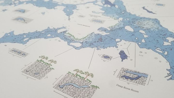
The first step in mapping is to measure the existing guide lines in the cave (survey). it is necessary to lay several lines in the galleries and rooms in order to measure the distances between the existing lines and the walls of the cave or the important places to be represented on the map.

We can summarize this step as the creation and drawing of the skeleton of the cave.
The second step is to return to the water with the drawing of the previously measured lines and to draw what we see in the form of symbols (wall, stalagmites, stalactites, columns, slope, sediment, rocks, ...)


The third step is to digitize on the computer drawings made under water via a program for the final publication of the map.

The progress of the project :
Start of the project in October 2017.
I started the mapping project of the Taj Mahal system from October 2017 to October 2019 i realized the cartography of the following sections:
Survey of a part of the system. (5 dives and 7 hours)
- Traverse Cenote Taj Mahal Cenote Sagrado. (28 dives and 47 hours)
- The cave area (17 dives and 31 hours)
- Waterfall passage and Steve Loft's (24 dives and 44 hours)
- Chinese Garden passage (25 dives and 45 hours)
- Deep bone room and downstream of Cenote Mangrova (13 dives and 26 hours)
A total of 112 dives representing 200 hours of total dive time and 400 hours of computer work digitizing the drawings.
Publication of the map of the cave area in July 2018.
Publication of the map of half of the Taj Mahal system in September 2019.

Target for 2020 :
Continue the second part of the project by mapping the following sections:
- The Room of Reflection and adjacent galleries
- The Jumna River passage and adjacent galleries
- The City of Age Loop
- The Twin Cenotes area and the connection with the Cenote Sagrado
- The area of Cenote City of Age and Cenote Nachich
And publication of the second half of the Taj Mahal system map.
I estimate this second phase to 150 dives of about 110 minutes each 500 hours of digital work.
This project is mostly self financed (80%), it has no commercial purpose, some sponsors help me by providing equipment in return for a visibility, about 20% of the costs are covered by the sale of Tee-shirts and Cards.
FaceBook page : https://www.facebook.com/Cenote-Taj-Mahal-Cartography-Project-997524630386244/
Thank you for supporting this project by making a donation.
------------------------------------------------------------------------------------
Cenote Taj Mahal Cartography Project
Le système de grotte Taj Mahal :
L’état du Quintana Roo au Mexique est un paradis pour la plongée en grotte, plus de 1500 kilomètres de galeries immergées y ont été découvertes et explorées. Mais seulement une infime fraction ont été cartographiées de manière précise.
Le système Taj Mahal est situé entre Playa del Carmen et Tulum, il fait partie des systèmes de grottes les plus visité de la région par les plongeurs spéléo et caverne de toute la planète. Cet ensemble de galeries de 10 kilomètres de long et qui comprend plusieurs Cenotes (entrées) fut exploré pour la première fois dans les années 1995 par des plongeurs spéléo de différents pays.
(*) Cenote : Ts’ono’ot en maya qui signifie puit sacré ou puit avec de l’eau. Un Cenote en terme géologique est une Doline ou Sinkhole en Anglais
Le projet :
Plusieurs survey (mesure des lignes de grottes) ont été réalisés par différentes équipes et plongeur spéléo depuis les premières explorations en 1995. Quelques cartographies ont également été réalisées mais seulement des cartographies partielle et peu précises.
Mon projet est de réaliser une cartographie précise de l’ensemble du système Taj Mahal afin de mieux connaître et protéger cette grotte mais également dans le but de donner au plongeur spéléo un support pour planifier au plus juste leur plongée spéléo.
Le cartographe :
Mon nom est David Mayor et je suis Française. Dans les années 90 j’ai découvert en France la plongée souterraine, ce monde m’a tout de suite fasciné. Cette fascination m’a conduit à devenir moniteur de plongée souterraine, explorateur et cartographe.

Les étapes du projet :
La première étape pour réaliser une cartographie est de mesurer les lignes guide (fil d’ariane) existante dans la grotte (survey). il est nécessaire de poser plusieurs lignes dans les galeries et salles afin de mesurer les distances entre les lignes existantes et les parois de la grotte ou les endroits important à représenter sur carte.
On peut résumer cette étape comme à la création et au dessin du squelette de la grotte.

La deuxième étape consiste à retourner dans l’eau avec le dessin des lignes précédemment mesurées et de dessiner ce que l’on voit sous forme de symboles (mur, stalagmites, stalactites, colonnes, pente, sédiment, roches, …)


La troisième étape consiste à digitaliser sur l’ordinateur les dessins réalisés sous l’eau via un programme en vue de la publication finale de la carte.

L’avancement du projet :
Début du projet en octobre 2017.
J’ai commencé le projet de cartographie du système Taj Mahal en octobre 2017 à ce jour d’octobre 2019 j’ai réalisé la cartographie des sections suivantes :
Survey d’une partie du système. (5 plongées et 7 heures)
-Traverse du Cenote Taj Mahal au Cenote Sagrado. (28 plongées et 47 heures)
- La zone de la caverne (17 plongées et 31 heures)
- Waterfall passage et Steve Loft’s (24 plongées et 44 heures)
- Chinese Garden passage (25 plongées et 45 heures)
- Deep bone room et le downstream du Cenote Mangrova (13 plongées et 26 heures)
Au total 112 plongées représentant 200 heures de temps total de plongé et 400 heures de travail informatique à digitaliser les dessins.
Publication de la carte de la zone caverne en juillet 2018.
Publication de la carte de la moitié du système Taj Mahal en septembre 2019.

Objectif pour 2020 :
Continuer la deuxième partie du projet en cartographiant les sections suivantes :
- The Room of Reflection et les galeries adjacentes
- The Jumna River passage et les galeries adjacentes
- The City of Age Loop
- La zone Twin Cenotes et la connection avec le Cenote Sagrado
- La zone de Cenote City of Age et Cenote Nachich
J’estime cette deuxième phase à 150 plongées d’environ 110 minutes chacune 500 heures de travail numérique.
Ce projet est majoritairement Autofinancé (80%), il n'a pas de but commercial, quelques sponsors m’aident en fournissant de l'équipement en contrepartie d’une visibilité, environ 20% des coûts sont couvert par la vente de Tee-shirts et de Cartes.
Page FaceBook : https://www.facebook.com/Cenote-Taj-Mahal-Cartography-Project-997524630386244/
Merci de supporter ce projet en réalisant un don.
The Taj Mahal cave system :
The state of Quintana Roo in Mexico is a paradise for cave diving, more than 1500 kilometers of submerged galleries have been discovered and explored. But only a tiny fraction has been accurately mapped.
The Taj Mahal system is located between Playa del Carmen and Tulum, and is one of the most visited cave systems in the area by caver divers and cavern divers from all over the world. This system of galleries of 10 kilometers long and which includes several Cenotes (entries) was explored for the first time in the years 1995 by divers cavers of different countries.
(*) Cenote: Ts'ono'ot in Maya meaning sacred well or well with water. A Cenote in Geological Terms is a Doline or Sinkhole in English
The project :
Several surveys (measurement of cave lines) have been carried out by different teams and cave diver since the first explorations in 1995. Some maps have also been made but only partial and inaccurate maps.
My project is to carry out an accurate cartography of the whole Taj Mahal system in order to better know and protect this cave but also in order to give the caving diver a support to plan their caving dive.
The cartographer :
My name is David Mayor and I am French. In the 90s I discovered in France the underground diving, this world immediately fascinated me. This fascination led me to become an underground diving instructor, explorer and cartographer.
The stages of the project :
The first step in mapping is to measure the existing guide lines in the cave (survey). it is necessary to lay several lines in the galleries and rooms in order to measure the distances between the existing lines and the walls of the cave or the important places to be represented on the map.
We can summarize this step as the creation and drawing of the skeleton of the cave.
The second step is to return to the water with the drawing of the previously measured lines and to draw what we see in the form of symbols (wall, stalagmites, stalactites, columns, slope, sediment, rocks, ...)
The third step is to digitize on the computer drawings made under water via a program for the final publication of the map.
The progress of the project :
Start of the project in October 2017.
I started the mapping project of the Taj Mahal system from October 2017 to October 2019 i realized the cartography of the following sections:
Survey of a part of the system. (5 dives and 7 hours)
- Traverse Cenote Taj Mahal Cenote Sagrado. (28 dives and 47 hours)
- The cave area (17 dives and 31 hours)
- Waterfall passage and Steve Loft's (24 dives and 44 hours)
- Chinese Garden passage (25 dives and 45 hours)
- Deep bone room and downstream of Cenote Mangrova (13 dives and 26 hours)
A total of 112 dives representing 200 hours of total dive time and 400 hours of computer work digitizing the drawings.
Publication of the map of the cave area in July 2018.
Publication of the map of half of the Taj Mahal system in September 2019.
Target for 2020 :
Continue the second part of the project by mapping the following sections:
- The Room of Reflection and adjacent galleries
- The Jumna River passage and adjacent galleries
- The City of Age Loop
- The Twin Cenotes area and the connection with the Cenote Sagrado
- The area of Cenote City of Age and Cenote Nachich
And publication of the second half of the Taj Mahal system map.
I estimate this second phase to 150 dives of about 110 minutes each 500 hours of digital work.
This project is mostly self financed (80%), it has no commercial purpose, some sponsors help me by providing equipment in return for a visibility, about 20% of the costs are covered by the sale of Tee-shirts and Cards.
FaceBook page : https://www.facebook.com/Cenote-Taj-Mahal-Cartography-Project-997524630386244/
Thank you for supporting this project by making a donation.
------------------------------------------------------------------------------------
Cenote Taj Mahal Cartography Project
Le système de grotte Taj Mahal :
L’état du Quintana Roo au Mexique est un paradis pour la plongée en grotte, plus de 1500 kilomètres de galeries immergées y ont été découvertes et explorées. Mais seulement une infime fraction ont été cartographiées de manière précise.
Le système Taj Mahal est situé entre Playa del Carmen et Tulum, il fait partie des systèmes de grottes les plus visité de la région par les plongeurs spéléo et caverne de toute la planète. Cet ensemble de galeries de 10 kilomètres de long et qui comprend plusieurs Cenotes (entrées) fut exploré pour la première fois dans les années 1995 par des plongeurs spéléo de différents pays.
(*) Cenote : Ts’ono’ot en maya qui signifie puit sacré ou puit avec de l’eau. Un Cenote en terme géologique est une Doline ou Sinkhole en Anglais
Le projet :
Plusieurs survey (mesure des lignes de grottes) ont été réalisés par différentes équipes et plongeur spéléo depuis les premières explorations en 1995. Quelques cartographies ont également été réalisées mais seulement des cartographies partielle et peu précises.
Mon projet est de réaliser une cartographie précise de l’ensemble du système Taj Mahal afin de mieux connaître et protéger cette grotte mais également dans le but de donner au plongeur spéléo un support pour planifier au plus juste leur plongée spéléo.
Le cartographe :
Mon nom est David Mayor et je suis Française. Dans les années 90 j’ai découvert en France la plongée souterraine, ce monde m’a tout de suite fasciné. Cette fascination m’a conduit à devenir moniteur de plongée souterraine, explorateur et cartographe.
Les étapes du projet :
La première étape pour réaliser une cartographie est de mesurer les lignes guide (fil d’ariane) existante dans la grotte (survey). il est nécessaire de poser plusieurs lignes dans les galeries et salles afin de mesurer les distances entre les lignes existantes et les parois de la grotte ou les endroits important à représenter sur carte.
On peut résumer cette étape comme à la création et au dessin du squelette de la grotte.
La deuxième étape consiste à retourner dans l’eau avec le dessin des lignes précédemment mesurées et de dessiner ce que l’on voit sous forme de symboles (mur, stalagmites, stalactites, colonnes, pente, sédiment, roches, …)
La troisième étape consiste à digitaliser sur l’ordinateur les dessins réalisés sous l’eau via un programme en vue de la publication finale de la carte.
L’avancement du projet :
Début du projet en octobre 2017.
J’ai commencé le projet de cartographie du système Taj Mahal en octobre 2017 à ce jour d’octobre 2019 j’ai réalisé la cartographie des sections suivantes :
Survey d’une partie du système. (5 plongées et 7 heures)
-Traverse du Cenote Taj Mahal au Cenote Sagrado. (28 plongées et 47 heures)
- La zone de la caverne (17 plongées et 31 heures)
- Waterfall passage et Steve Loft’s (24 plongées et 44 heures)
- Chinese Garden passage (25 plongées et 45 heures)
- Deep bone room et le downstream du Cenote Mangrova (13 plongées et 26 heures)
Au total 112 plongées représentant 200 heures de temps total de plongé et 400 heures de travail informatique à digitaliser les dessins.
Publication de la carte de la zone caverne en juillet 2018.
Publication de la carte de la moitié du système Taj Mahal en septembre 2019.
Objectif pour 2020 :
Continuer la deuxième partie du projet en cartographiant les sections suivantes :
- The Room of Reflection et les galeries adjacentes
- The Jumna River passage et les galeries adjacentes
- The City of Age Loop
- La zone Twin Cenotes et la connection avec le Cenote Sagrado
- La zone de Cenote City of Age et Cenote Nachich
J’estime cette deuxième phase à 150 plongées d’environ 110 minutes chacune 500 heures de travail numérique.
Ce projet est majoritairement Autofinancé (80%), il n'a pas de but commercial, quelques sponsors m’aident en fournissant de l'équipement en contrepartie d’une visibilité, environ 20% des coûts sont couvert par la vente de Tee-shirts et de Cartes.
Page FaceBook : https://www.facebook.com/Cenote-Taj-Mahal-Cartography-Project-997524630386244/
Merci de supporter ce projet en réalisant un don.
Organizer
David MAYOR
Organizer
Toulouse, B3