Digital Denali
Donation protected
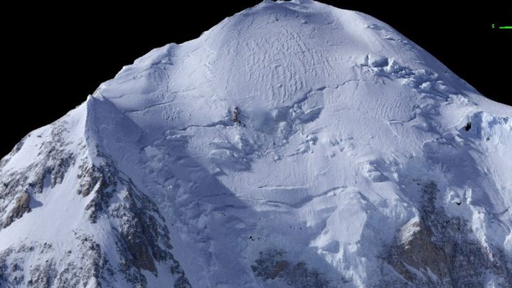
My family and I created the best digital topographic map ever made of Denali, the tallest mountain in North America, on 8 April 2018, using fodar, an airborne photogrammetric technique. The data are fully processed and validated, with a resolution high enough to see climbers' tents and with an accuracy to within about a foot. We had no sponsor for this work but we'd like to make these data available publicly, as well as continue to make more such maps as a public service to study changes to glaciers, improve climbing safety by assessing changes to climbing routes, and potentially assist with searches for missing climbers in near-realtime. By working together, we can make that dream a reality!
We've already reached half our goal. Please consider donating $20.308 (or round up to $20.31) to commerate the elevation of the peak that we measured. With only a few hundred such donations, we can continue mapping the mountain to understand is as yet undiscovered dynamics!
You might ask, don't my tax dollars already go to funding things like this? It's true, a lot of tax dollars do support science, and I have successfully received some of that funding in the past for many other projects in my 25 years at the University of Alaska . But the true cost to the tax payer is 2-3 times what actually goes to science due to bureaucracy, and even spending small pots of money can take the government months to years. Because of this, I believe crowdfunding can achieve so much more for so much less money. Alaska's landscape is changing, but we barely know how. Nature isn't going to wait for the laborious process of traditional tax-funded science to come online. We need to start capturing the state of this topography now if we want to know how it's changed in the future.
This is our first attempt at crowdfunding mapping data so it's difficult to guess what the response will be in terms of funding. We are not looking to make a profit on this project, but we do have costs that need to be covered to do this sustainably. Properly processing the data and analyzing it takes time and specialized hardware/software, and I'd like to involve other experts in review. Publicly archiving the data is probably my last choice for enjoying a pleasant Sunday afternoon, and it will take several of those. I'd also like to create a paper contour map which can be used in the field or at home, and that has its own costs and lots of time. Plus the costs of owning, operating, maintaining, and insuring 60 year old airplanes adds up faster than we'd like. So we've started with a $5000 goal to archive these data for non-commercial use. And we are also not a non-profit, so contributions are not tax-deductible. If we don't reach our goal, we'll use that funding to try work with the government to purchase the data to archive it themselves, to keep the 3D visualizations online, and to work on related efforts. For each $5000 we exceed our goal, we will make another map as time and weather permit. So the more you fund, the more maps we make, and the more we all learn!
Everything helps! Your contributions will be greatly appreciated and allow us to continue to advance the scientific study of our remote, beautiful and changing public lands in Alaska. Ultimately the government may start funding contracts for mapping Denali now that we've demonstrated it's possible, but our landscape isn't going to stop changing in the meantime!
Visit www.fairbanksfodar.com to learn more.
Organizer
Matt Nolan
Organizer
Fairbanks, AK


