Samloem Wildlife database Cambodia
Hello Guys, My name is Stephanie and i have been living in Cambodia for the past year on the islands south of Sihanoukville, Koh Rong and Koh Rong Samloem.
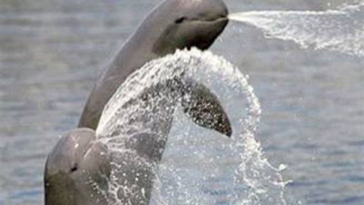
Koh Rong Samloem is a massively diverse island situated in the indo-burma biodiversity hotspot surrounded by coral reefs, seagrass beds and mangrove trees and colonised by grassland, ancient dunes, rainforest, ancient woodland among others and supports a wide range of marine and terrestrial species. It's tourism infrastructure is only four years old so there is still so much endemic and undiscovered wildlife to study and understand. Rare and endangered species like the Irrawaddy dolphin and heavily traded species such as the Asian palm civets, sunda pagolin and slow loris to name a few can be found here but with increasing tourism and rich tycoons the island is being overwhelmed by investors wanting to convert rare habitats that support so much wildlife.
I am setting up a project and working with international organisations (flora and fauna.org), local business owners (the Diveshop) and resident wildlife fanatics that have much experience with the wildlife in the island so we can record both terrestrial and marine species, where they are found and at a later date study their behaviour to understand how island pressures with human presence differs from the behaviour or mainland species. This research will be used to improve the conflict between wildlife and the locals, educate visitors to the island, create a better understanding of island pressures and raise awareness both nationwide and internationally. There is also high levels of scientific research that can be conducted here for medincinal benefits studying marine organisms.
The funding will be used for equipment during the study, to building matreials to complete stages of the project, professional expertise, to create and publish a website containing all the information recorded, to set up seminars to teach visitors and locals about the wildlife and living expenses while the surveys are being conducted. If you want to learn more about our project we have provided our stage by stage goals below:
The first stage of the project is to document the wildlife (both flora and fauna) found along the main jungle trails and beaches (sunset beach and trail, Saracen beach, lazy beach and trail, lighthouse beach and trail, M’pai bai trail and beach) providing any details about their location, type of day (sunny, windy, raining, cloudy etc), temperature. Adding background data about the species and any inter and intraspecific connections to other species. Using their GPS coordinates each species will be input into a GIS map which will be used to educate visitors and residents. This data will be made available through the use of an interactive website (this will not be available immediately) and application for educational purposes to raise awareness and offer an ecological aspect to the tourism on the island. The creation and establishment of mooring buoys will begin during the first stage of data collection at the most active dive sites. This will reduce any impact the projects marine data surveys may have on the reef and any other dive companies or boats that are in the area.
Stage 2 is the same as stage 1 but this is the recording the marine sites around the island and the sites will be recorded as well as photographed to gather as much information about the coral reef systems and the species that reside in it. This data will be added to the GIS map with the relevant background data and inter and intraspecific relations. We intend to record the dawn, day and night at each dive site as the ecology changes with the time of day.
The following stage will be recording the areas of land through the island. Due to the size of the island it will have to be segmented into sites small enough to survey efficiently (the current boundaries are unknown yet). Once the boundaries are established an initial walk to mark out safe transect routes (the topography varies throughout the island and there are several venomous snakes, insects and other dangerous species) to minimalise risk and maximize health and safety throughout the project. Markers will be made using GPS and paint. This stage will also establish the points of interest (also marked by GPS point and paint); high productivity, animal activity, water sources etc which will be used in night time video recordings for specie presence and behavioural analysis. The transects will aim to be every 10m depending on terrain and will striate through the land (using a compass as well as GPS and paint) until it reaches the site or island boundary. Transect point and points of interest will be colour coordinated to prevent confusion. This process will be repeated for every site established but the transects may alter between longitudinal and latitudinal depending on the lye of the land and the site.
Striated transects from north to south and east to west will be made however the spacing between each transect hasn’t been established yet. Surveying methods can only be made upon the second transect walk as the first walk will established the survey methods required for the area and allow me to locate points of interest or hotspots on the island (e.g. tea tree lakes). Once the transects are established survey will continue to be made for a 6 month period (this is depending on the number of volunteers as each transect needs to be surveyed at least 4-5 times and this is also depending on how many survey methods required).
Stage four is the recording of the marine areas between the dive sites using video photographs to record the habitats and species and any behaviours exhibited. This is to ensure all areas of the island are recorded. There may be a reason why the coral cover is low or the area is low in productivity and diversity. However this survey may not be possible if the currents are strong, further research into the seasonal currents is needed.
Stage 5 will comprise all the data both terrestrial and marine on the website and background information about each species will be included some of this data may have been taken from the corresponding Facebook page for this project. The length of time this stage will take is dependent on the number of volunteers available and species found.
Stage 6 can only be initiated once all transect and marine surveys have been made. This is the behavioural studies section. Now that we have established where the points of interest area on land and we have a compilation of videos for each dive site we can note the behavior the individual species have with their environment and other species. More specific methods for these studies will be ascertained closer to the time of initiation as the species for study are currently unknown.
The final stage of the data collection project will input all the behavioural data and establish the more complicated relationships between species and habitats. A final ecosystem map will be made available online and analysis of the overall data from the island.
Now all the data has been collected and mapped the analysis of the key areas and species that provide benefits for the resident’s livelihood. A report will be made indicating these areas and educational presentations will be produce using the data to outline a step by step from the relationships between the species and habitat to how it produces the ecosystem services and processes and finally outlining how we utilize it and the impacts the current ways are causing then providing alternative solutions. The initial report will also be forwarded to any organizations (i.e. MFMA) involved to be used for educational purposes and to improve governing infrastructure.
Organiser
Hippy At Heart
Organiser