Dan's Drone research
Donation protected
Abstract
We are witnessing the advent of a new era of robots — drones — that allow us all new ways to view and analyze our world, totally autonomously with very little human input. These robots, often associated with defense applications, could have a major impact on civilian tasks including agriculture, disaster mitigation, environment preservation and communication. Autonomous flight in our already congested airspace presents great technical challenges, on top of everything else owing mostly to the energetic cost of breaking the most fundamental of laws: gravity. Through precursor work on my own I've identified some of what I feel to be the most promising up and coming applications which need exploring as well as my own plan to develop drones specially for agriculture work. Now I'm asking you to join me in my pursuit of where this exciting new technology may lead us.
Original campaign description:
Hello everyone, this is my first ever crowdfunding campaign and as such I'm following the advice I read most of "keep personal info about you short and to the point and just get to the meat of what you're doing" so here's my two paragraph intro...
I'm Dan Gostlin and I'm a computer nerd and I am passoniate about developing new technologies to better our world. I also run the daily upkeep and general operations at RiverGo equestrian center, a working horse farm located here in Columbus and surronded by nearly three hundred acres of cropland I get to experiment on. As I'm sure you know, or at least have seen me post about on social media my hobby is "drones". Big scary subject I know and one lots, if not most people know little about, or are even scared of because it's just such a new technology. I'm not most people; I am a developer for the Cleanflight project. This is an open source (that means free in computer lingo) flight controller software, and the hardware it runs on, put together by a group of like minded computer programmers and other hobbyist dedicated to bringing relatively cheap, easy to setup but pretty powerful systems to the average recreational flier who wants to go out and fly for any of a number of reasons but it isn't necessarily well suited for more scientific research type of drone operations. Being very easy to setup and get started with is it's main goal and infact the end-user never even has to read a single line of code, let alone understand or write it if he doesn't want to, Cleanflight can be configured completely through a Graphical User Interface or even using a mobile device! This is great to advance the hobby but again my goal being actual research it's time I leave CleanFlight behind and go out on my own!
Currently the number one use of hobby grade drones is pure recreation, the hobby itself is in it's infancy and the impact these drones will have on our lives is vastly unexplored. Now that I've been flying with, and contributing to Cleanflight for a while I'm starting to gain a better insight of where I personally would like to see commercial and private use of drones going as the technology comes into maturity.
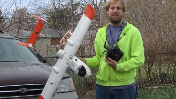
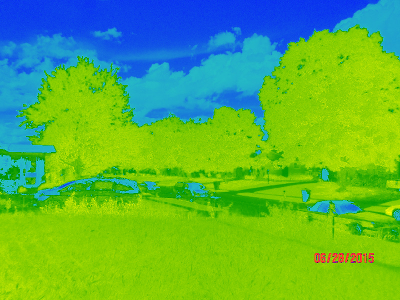
This wonderful new technology enables us as regular people to have access to unprecedented ways to view our world and gather data on all sorts of things, let me bring up my beliefs where I intend to focus my research and development and [hopefully] I'll be able to come up with some all new ways to use uUAV (that's micro Unmanned Aerial Vehicle) technology. My first idea I want to explore is farming. Right now if a farmer wants to gather data about his crop or his livestock his options are VERY limited. Don't believe me, walk out to the middle of a corn field and take a look around, know what you see? Corn, for about 3 feet in every direction cause it grows 8' tall and plants grow two inches apart so thick you literally can not see through it! Not much data to be gathered from that prospective huh? Mid growing season you could be standing six feet from a dead patch and you'd have no clue cause you just couldn't see it past the next five rows of the living plants (true story, see picture)
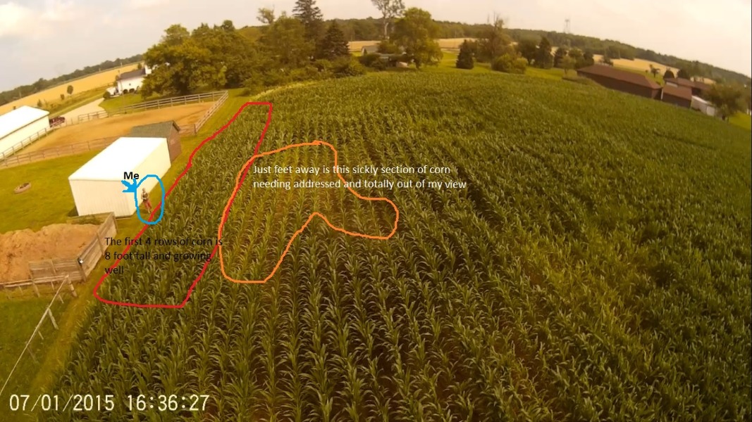
In this image we can see just how hard it is to find and ID problem areas from the ground, you see me standing at the edge of the corn, just four or five rows in we run into struggling plants, I absolutely can not see this from the ground at all!
Right now the ONLY other option is to pay a HUGE amount of money for a real life pilot to fly over your field (average price starts around $600 PER HOUR and only goes up from there) and he'll come out, fly over and take a few normal pictures then bring you those pictures and say "here you go". Oh you want shots from a different angle? Guess what, that's another job. Pay up. With drones it's a battery change and a few buttons on your ground station to select a different route and it goes out and takes up to hundreds of more pictures for you for zero additional cost!
So Dan, tell me, what is it a drone can offer that a real plane, with a real pilot cant? Good question, first off is safety. No matter how spotless of a safety record a pilot with a full scale / manned aerial photography company has safety is always a huge concern with anything aviation. You are after all using a machine, and a computer (which we all know "crash" all the time) to literally break one of the most fundamental laws of the universe: gravity! Accidents do happen, period. If [when] a real plane or helicopter goes down you can expect loss of life and you can expect jet fuel and other toxic fluids to be dispersed all over the crop field, even if they don't ignite the crop is ruined and likely so is the soil they're growing in, then needing to be dug up and trucked off and disposed of as a haz-mat material. Know what happened when a uUAV goes down? The operator is out a little bit of money, that's it... Environmental disaster averted!
If you're familiar with FAA regulations at all you will know a real plane has many MANY rules that must not be broken, they can not for any reason fly below 400', ever seen an ear of corn at 400'? Doesn't look like much... A drone can literally skim across the tops of these crops taking pictures and sensor readings, even stopping to gathering physical samples of soil, of the air quality, even of the plants themselves for later analysis by the farmer without him having to use a single drop of fuel to go out into the field in his tractor.
REAL LIFE, EXISTING APPLICATION:
There is an widely used crop survey technology called NDVI (that's Normalized Difference Vegetative Index) that's used by NASA and the ESA on satellites in space to take readings of VERY large areas of plants, say whole rain forests or millions upon millions of acres of grassland. Resolution is good for being taken from about 122 miles above earth but from space "good" is relative, working out to several square kilometers per pixel. Myself, as well as lots of other small time researchers in the uUAV field have already been experimenting with NDVI photography from drones but the ways which we interpret the data and will be able to help the farmer is still vastly unknown. Fields to explore how drone captured NDVI can help us include bio control, crop production, soil & water quality, weed control and waste management (especially concerning run-off fertilizers).
One of my goals over the winter is to partner with a local farm to conduct on-farm testing of such systems in an applied environment and to provide him real world feedback that he can turn into higher yield that’s better for the environment using practices like selective application of fertilizers and treating issues with preventative measures, instead of reacting to problems after they occur. The goal being to both help him to up his yield (in turn helping all of us with a larger food supply) as well as decreasing the negative impact farming has on the environment and to help develop new sustainable farming methods.
So far I've bought and experimented with several cameras, mostly Canon point and shoot digital cameras cause they're easier to convert the lenses on and take good pictures and run an open source firmware called Canon Hacker Development Kit. Another open source firmware that gives the user total control of all the cameras settings and also allows control of zoom and shutter via remote input, both from the user on the ground and autonomously, triggered by waypoints in the flight controllers route.
These are the camera's I've experimented with,
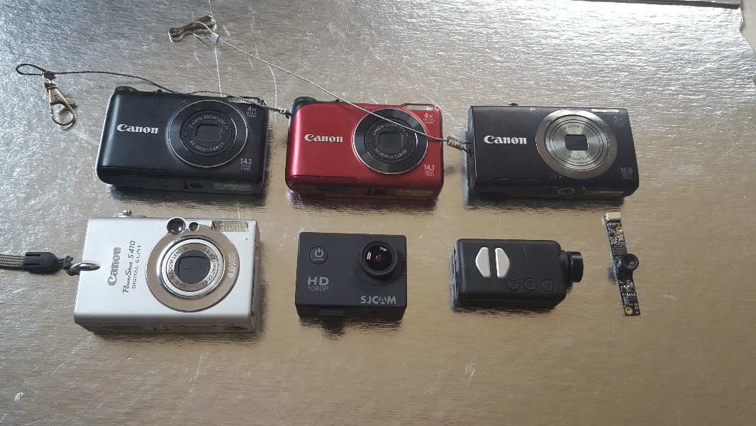
Four of which I currently use, a Canon A2200 for NDVI, Canon A2300 for HD 16.1mp still pictures, SJCAM SJ4000 for 1080p video, Mobius action cam for 720P video.
Here we have two calibration images taken by the pair of Canon A2200's (each has a different type of lens). Raw [top] and then post-processed NDVI image [below]. In the first set the green color shows the trees and grass are lower than the ambient temp, indicating those plants are activle transpiring, if they were sick they would show up (in the post-processed image) as red-orange.

Depth in the raw image it a little hard to descern here cause it's taken at to high of an angle but wa can see the swash in the center of the RAW is a bit taller and a little more robust looking, when we process it into NDVI we see just that, the center patch is green with the shorter, pweney looking ones getting warmer and warmer till they are at air temp (an active transpiring plant will be ~10F below air temp) and blend in with the background color
There's also numerous other mundane tasks a drone could perform on a farm: jumping over to livestock, machine vision equipped drones could be deployed to check on and take count of heads of cattle and even monitor the amount of feed in a pile (bales of hay or the amount of grain in volume). A micro class drone could be deployed at the end of each day to run an autonomous route to go around and it could check every gate was closed and each pasture was empty and make sure no stragglers were left behind and no animals can escape that night. If it found an alarm condition (a gate being unlatched or an animal being somewhere it shouldn’t) it could send you a text message to your phone or an email (again this aspect is a true story, drones today are equipped with 4G LTE radios built in!) Once it's completed it's inspection it would be programmed to return to it's dock and charge itself and wait till it was deployed for the same mission the next night. They could be used for so many different tasks around the farm the possibilities at this point are quite literally unknown. Automatically locating missing animals or even predators is another potential use that a ground based system simply can not be made to do.
Here's a short clip of me flying one of my mini class tricopters threw the main aisle at RiverGo Equestrian center. I was operating it here via FPV but with the right sensors and programming one could be made to do this on it's own, even checking the locks and reporting to a computer or mobile device if open doors were found!
(video credit : ME!!!)
This is a short 90sec demo video of a FLIR Vue camera. (video produced by FLIR as advertising material). Note unfortuniately they produced the video before final pricing was released and the prices quoted in the video are several hundred bucks low, please see the product link I've attached in my wishlist to see what it will actually cost me.
(video credit : FLIR)
One very interesting newly developed system is, as I touched on above, the ability to take high res photo based volume measurements. Be it bales of hay and animal feed or on the construction site or even at landfills. VERY accurate approximations can be computed just from aerial images with no special sensors required, all done in post processing after the drone has landed safely back at it's base. This is a routine task employed literally daily all over this country, the question here isn't "if", more of a "what all can we apply this already existing technology to?"
Here you can view a demo video from the company Airborne-Robitics showing this process and how it's already being used on jobsites around the world. Again my goal is to devise new ways to use this already put into practice technology. (video is approx. 3:30 long)
(video credit : Airborne-Robotics )
All those potential uses STILL doesn't interest you? Ok lets talk about some other ideas..
DRONES SAVE LIVES!
This story from Texas during last hurricane season (apparently they love them their drones down there as much as their other freedoms, there are numerous stories just like this all over the net). A woman drove her pickup into too fast moving of a creek and was quickly washed down stream. This time another volunteer, using his dji Inspire 1 found the truck and, using the live video feed back to base directed rescuers in a hovercraft to her within another minute, moments before the truck was fully submerged by the quickly rising stream.
Man these stories are great aren't they, I wonder why the mainstream news doesn't ever report these types of drone stories...
(video credit : Garret Bryl)
--This is what I'm asking of you--
What I'm hoping for by running this crowdfunding campaign is to gain some venture capital to be able to buy equipment I personally need to further develop my own ideas of what an agricultural drone might be capable of. Equipment that, simply put is way out of reach price wise on my own. There's a myriad of cameras and sensors that can be attached to small drones: high resolution, high frame rate visible light cameras that take[very high quality] regular pictures, 3D cameras that can make a single pass threw an area and record everything, in all directions at the same time (an extremely new and very exciting technology, see clip below and use your mouse or simply look around any direction just by moving your phone). There’s NDVI imaging cameras to monitor plant life, FlIR cameras to "see in the dark" (these see heat signatures instead of light). Other than cameras air quality, temperature and gas sensors can be mounted to monitor CO2 emissions and oxygen uptake from the plants "breathing" process (photosynthesis).
Make sure you "look around" while watching this video, it's shot with a 3D camera!!
(video credit : DarkBack2 of FliteTestForums)
So far I've been able to build a few smaller multicopter type drones capable of partly autonomous flight and able to take visible light images as well as NDVI images but by far the most cost prohibitive aspect is the sensors and cameras themselves. Believe it or not in this day and age the drone is the "cheap part" (in a relative sense). This is where you come in. What I am asking of you is to donate whatever you can to me personally to help me fund my self-guided research into the advantages to us all which drones can provide on a small scale. There’s no government or big business pressure on me to monitize the outcome, there’s no hidden agenda, just a pure desire to discover and solve these world issues.Together we can make a difference. Unlike real life planes and satellites or any other high-level technology, for the first time in history we the people have the power to innovate, all I need is your help!
Money I receive as part of this campaign won’t go to developing toys for rich kids, it won’t go to buy me a new model to fly around my back yard and play with and it wont go towards the existing CleanFlight project... All money raised will be devoted to directly helping me buy equipment to further explore the different private sector uses of drones in agricultural, construction, emergency SAR and other small scale operations. The single largest purchase I need to make is a FLIR camera (this is one piece of equipment for both AG survey and life saving uses) as well as a spare flight controller for bench testing without having to physically put "money in the air" as we say.
I have set a goal of $4500, the FLIR camera alone is $3,200 but may be able to be sourced used for less. I already have two multirotor drones capable of carrying it, my largest can stay aloft for 20 minutes and hold it's own position or run short routes. Unfortunately however this isn't enough time to do much searching while trying to locate a victim then staying overhead while directing rescue workers nor is it enough to completely map even just a mid sized field so the rest of the money, above the price of the camera, will be used to fund a medium sized fixed wing uUAV (approximately 2 meters wingspan) which will be able to stay aloft 40-60 minutes or more while flying fully autonomously from a Linux based processor about as powerful as the one in your new iPhone (in comparison CleanFlight runs on a small 32 bit processor more comparable to what your IBM desktop computer was in 1996).
***So that I'm in compliance with GoFundMe's rules and regulations I need to be very clear about how money raised will be used: All money raised will go directly to fund my my personal research purchasing equipment and tools I need. In the name of full transparency I will not be donating or otherwise redistributing any funds from this to any other projects or developers (tho as always, all research will be made freely available to the community via my blog). When you donate you are helping fund ME directly. The biggest single purchase I need to make is the FLIR Vue camera, please see it and some of the other largest items I hope to be able to afford in the wishlist attached to this campaign.***
Now I realize $4500 is being VERY optimistic but I have faith in my group of friends, if however it turns out to not be possible I have selected a type of campaign that allows me to keep any funding even without meeting the goal and I'm really hoping that at the very least this will raise enough to get the plane built and flying with it's linux flight controller, I can then use my existing cameras and other flight gear in a long duration, long range plane instead of my existing power hungry multicopters.
Below you will see my wishlist. Most of it is big money stuff, things like wire (about 100 meters of wire goes into one of these small models), solder, connectors, shrink tube, lighting and misc. systems that are to common and numerous so I've added some overhead to the price over just the cost of the few biggest components. I know research like this might seem low down on where you personally see the world going but I offer you this view: I'm one person, just an amature, I didnt even go to school for anything related to this. What I'm doing is the American capitalistic story- guy has an idea, guy puts his heart and soul into idea trying to change the way something runs but ends up out of money before he even gets to give it a shot cause he's just a regular guy with family and pets and bills and more important expenses.
Also one final tid-bit... The store that I buy all these parts from (even the camera) is a local family owned hobby shop, ReadyMadeRC, right here in central Ohio. Not only is your money going to support me, the money I spend is going to support another local business! What's more american that supporting fellow Americans?! Thank you, and God bless the United States of America. Have a good one!
UPDATE 1 11-9-2015
I'd like to take a minute to say thank you to everyone who's supported me so far. Yes there's only four backers and I've raised just 3% of my goal however I've been getting friends requests on FB because of this (more people is always a good thing). There have been fifty shares (using the share button at the bottom of the campaign) and numerous more shares threw facebook (that GFM cant count). Thank you all! WE can do this and WE can make a difference! This is how WE make change happen!
Now I have some good news to announce. There is a company called Harvesting.co who runs a internet based dashboard for AG drones to keep their research on track, keep their data organized and it's setup in a way that the end user (farmers) can best use the data to track what's happening on the ground. It's a new service that they're started offering and as such they're giving out limited-function free trials.
Well I contacted them with what I'm doing and they upgraded my free trial to be unlimited access to all the tools they offer! I have access to all features and they're even including me in their personal email chain when they're discussing the app on their end, what changes need made and planning new features and stuff to add.
This is really exciting! I mean just the dashboard as it already runs is pretty cool but for them to put me on the development side of things for it, and to give me full un-retarded access really shows they believe in the research I'm doing!
Again a big thank you to everyone that's helped me out already and a big thank you to Harvesting for bringing me in on the ground floor! I'm sure this is a partnership that can help both of us in the long run! Please keep spreading the word guys.
UPDATE 2 11-17-2015
Not much research related news to report but I've made some changes to the campaign layout today and added an abstract like piece at the very top. GFM is setup more for product development based campaigns where the updates should be newest first but I think they should allow people running research based funding campaigns like me to use a different template (right now there is no choice, I've emailed them to express my concern lol).
In more exciting news I did finally get my ND4 filter put on my GoPro yesterday and got to fly it today. I was very happy with the images. A Neutral Density filter is like sunglasses for your camera, allowing the shutter to run slower eliminating some of the motion blur and the rolling shutter effect sometimes encountered on a drone mounted camera ("jello" as it's called in the industry). To bad the sun wasnt out to really test it, all I did was fly up to about 130ft in the back yard tho and shot some video. Wheather looks good later this week for a real test.
UPDATE 3 11-21-2015
Hello everyone, with the holidays coming up I realize it's just not a good time of year to ask for money and my overall goal is very ambitious, at this point I have declared a "sub-goal" of just $425 more that where I'm at now. All I need heading into the winter off-season is the Linux (Rasberry Pi) based micro computer and the Navio+ flight shield and flight control equipment, I dont physically need the plane or the FLIR camera till it's time to start flying next planting season.
Using an emulator and other bench testing equipment I can simulate, test and refine many code related aspects of my final project without having to put anything in the air at all. This is a much more obtainable goal and I believe lowering it to make it so I'm further along will help me gain more backers at this stage.
To reiterate, the final end project goal is still the original amount [$4500] but when you direct people to the page it will look like the project has reached a higher percent and hopefully that will drum up even more support that it already has. If I can reach the sub-goal before this Christmas I would be very well setup going into the early part of next spring. That's what prompted the change in the posted goal.
From now on I will be using this space for the most pressing, and only the most current updates and to ensire followers / backers receive email notifications.
All project / research related updates are being added to the bottom of the main post at semi-regular intervals so it's easier to read and keep up. Please scroll to the bottom for the most currently added info.
Update 4 11-25-2015
Even tho I've only raised $150 here (and a bit in cash donations) I've been a thrifty shopper and with Black Friday sales I've been able to purchase both the flight controller IMU board (still need the Raspberry Pi 2 computer before the flight controller is actually complete and ready to go, it's a two part system) and on top of that I've also bought the air frame it's self! Got one heck of a deal on both but the airframe was especially good! I was able to buy it open box from Ready Made RC so I got to support a local business while still getting a better than "used" price.
I've already got the IMU code of the flight controller setup and initialized, it wont be flying till I get a RasPi2 but I'm WAY FURTHER ahead than I should be with only a few hundred bucks! Thanks again everybody for making this possible. Last update I was concerned what time of the year it was would make it more difficult cause no one had money to give, now I'm grateful; had it not been for the Black Friday sales I would still be several hundred bucks away from either item, now I've got the plane and I'm just $45 from the flight controller [hint hint]...
I'll be picking the plane kit up Saturday, here's the IMU unit now.
One final note: Please check my updated wishlist. Because I was able to save over $500 on the plane and flight controller (originally I had $850 budgeted for them) I updated the list to include a long range radio system. Right now I use a 2.4ghz FHSS radio which gives me about 2 miles of range out in the country away from stray WiFi signals and cell phones but a 433mhz long range system is about 10 times more powerful. 2.4 is also the same type of wireless signal used for Wifi networks and bluetooth toys and missions upon missions of household things so range suffers drastically in the city. With a LRS (and my HAM license) I can expect to have full control well over 20 miles out (not that I'd ever need to fly that far away) and since it's an FCC controlled and license-required frequency there's no interferance in populated areas but the main advantage is it's a full duplex radio link, that means radio command and telemetry data are sent over the same radio, both ways at once. This eliminates the need for a stand alone telemetry system as well as puts the data right in the palm of my hands [literally] on my transmitter screen instead of only on the small display in my ground station.
a 433mhz system is really the IDEAL system for this kind of work. Again nothing wrong with my current 2.4ghz system, it works well and is more than safe enough. The two-way protocol is the main advantage that makes it worth it to upgrade.
Update 5 Black Friday:
Had a great Black Friday, what I had planned on costing over $1000 I paid under $300 for! I now have the complete air frame (budgeted for $499, paid $100), the IMU unit (budgeted $255, paid $85 and I got a brand new RaspberryPi Zero for just $5 on a super freaking awesome Black Friday sale). I have components laid out in the fuselage and wiring started. Hopefully I can be flying it before Christmas...
*All photos copyright Dan Gostlin 2016, all videos credit to their noted owners)
We are witnessing the advent of a new era of robots — drones — that allow us all new ways to view and analyze our world, totally autonomously with very little human input. These robots, often associated with defense applications, could have a major impact on civilian tasks including agriculture, disaster mitigation, environment preservation and communication. Autonomous flight in our already congested airspace presents great technical challenges, on top of everything else owing mostly to the energetic cost of breaking the most fundamental of laws: gravity. Through precursor work on my own I've identified some of what I feel to be the most promising up and coming applications which need exploring as well as my own plan to develop drones specially for agriculture work. Now I'm asking you to join me in my pursuit of where this exciting new technology may lead us.
Original campaign description:
Hello everyone, this is my first ever crowdfunding campaign and as such I'm following the advice I read most of "keep personal info about you short and to the point and just get to the meat of what you're doing" so here's my two paragraph intro...
I'm Dan Gostlin and I'm a computer nerd and I am passoniate about developing new technologies to better our world. I also run the daily upkeep and general operations at RiverGo equestrian center, a working horse farm located here in Columbus and surronded by nearly three hundred acres of cropland I get to experiment on. As I'm sure you know, or at least have seen me post about on social media my hobby is "drones". Big scary subject I know and one lots, if not most people know little about, or are even scared of because it's just such a new technology. I'm not most people; I am a developer for the Cleanflight project. This is an open source (that means free in computer lingo) flight controller software, and the hardware it runs on, put together by a group of like minded computer programmers and other hobbyist dedicated to bringing relatively cheap, easy to setup but pretty powerful systems to the average recreational flier who wants to go out and fly for any of a number of reasons but it isn't necessarily well suited for more scientific research type of drone operations. Being very easy to setup and get started with is it's main goal and infact the end-user never even has to read a single line of code, let alone understand or write it if he doesn't want to, Cleanflight can be configured completely through a Graphical User Interface or even using a mobile device! This is great to advance the hobby but again my goal being actual research it's time I leave CleanFlight behind and go out on my own!
Currently the number one use of hobby grade drones is pure recreation, the hobby itself is in it's infancy and the impact these drones will have on our lives is vastly unexplored. Now that I've been flying with, and contributing to Cleanflight for a while I'm starting to gain a better insight of where I personally would like to see commercial and private use of drones going as the technology comes into maturity.
This wonderful new technology enables us as regular people to have access to unprecedented ways to view our world and gather data on all sorts of things, let me bring up my beliefs where I intend to focus my research and development and [hopefully] I'll be able to come up with some all new ways to use uUAV (that's micro Unmanned Aerial Vehicle) technology. My first idea I want to explore is farming. Right now if a farmer wants to gather data about his crop or his livestock his options are VERY limited. Don't believe me, walk out to the middle of a corn field and take a look around, know what you see? Corn, for about 3 feet in every direction cause it grows 8' tall and plants grow two inches apart so thick you literally can not see through it! Not much data to be gathered from that prospective huh? Mid growing season you could be standing six feet from a dead patch and you'd have no clue cause you just couldn't see it past the next five rows of the living plants (true story, see picture)
In this image we can see just how hard it is to find and ID problem areas from the ground, you see me standing at the edge of the corn, just four or five rows in we run into struggling plants, I absolutely can not see this from the ground at all!
Right now the ONLY other option is to pay a HUGE amount of money for a real life pilot to fly over your field (average price starts around $600 PER HOUR and only goes up from there) and he'll come out, fly over and take a few normal pictures then bring you those pictures and say "here you go". Oh you want shots from a different angle? Guess what, that's another job. Pay up. With drones it's a battery change and a few buttons on your ground station to select a different route and it goes out and takes up to hundreds of more pictures for you for zero additional cost!
So Dan, tell me, what is it a drone can offer that a real plane, with a real pilot cant? Good question, first off is safety. No matter how spotless of a safety record a pilot with a full scale / manned aerial photography company has safety is always a huge concern with anything aviation. You are after all using a machine, and a computer (which we all know "crash" all the time) to literally break one of the most fundamental laws of the universe: gravity! Accidents do happen, period. If [when] a real plane or helicopter goes down you can expect loss of life and you can expect jet fuel and other toxic fluids to be dispersed all over the crop field, even if they don't ignite the crop is ruined and likely so is the soil they're growing in, then needing to be dug up and trucked off and disposed of as a haz-mat material. Know what happened when a uUAV goes down? The operator is out a little bit of money, that's it... Environmental disaster averted!
If you're familiar with FAA regulations at all you will know a real plane has many MANY rules that must not be broken, they can not for any reason fly below 400', ever seen an ear of corn at 400'? Doesn't look like much... A drone can literally skim across the tops of these crops taking pictures and sensor readings, even stopping to gathering physical samples of soil, of the air quality, even of the plants themselves for later analysis by the farmer without him having to use a single drop of fuel to go out into the field in his tractor.
REAL LIFE, EXISTING APPLICATION:
There is an widely used crop survey technology called NDVI (that's Normalized Difference Vegetative Index) that's used by NASA and the ESA on satellites in space to take readings of VERY large areas of plants, say whole rain forests or millions upon millions of acres of grassland. Resolution is good for being taken from about 122 miles above earth but from space "good" is relative, working out to several square kilometers per pixel. Myself, as well as lots of other small time researchers in the uUAV field have already been experimenting with NDVI photography from drones but the ways which we interpret the data and will be able to help the farmer is still vastly unknown. Fields to explore how drone captured NDVI can help us include bio control, crop production, soil & water quality, weed control and waste management (especially concerning run-off fertilizers).
One of my goals over the winter is to partner with a local farm to conduct on-farm testing of such systems in an applied environment and to provide him real world feedback that he can turn into higher yield that’s better for the environment using practices like selective application of fertilizers and treating issues with preventative measures, instead of reacting to problems after they occur. The goal being to both help him to up his yield (in turn helping all of us with a larger food supply) as well as decreasing the negative impact farming has on the environment and to help develop new sustainable farming methods.
So far I've bought and experimented with several cameras, mostly Canon point and shoot digital cameras cause they're easier to convert the lenses on and take good pictures and run an open source firmware called Canon Hacker Development Kit. Another open source firmware that gives the user total control of all the cameras settings and also allows control of zoom and shutter via remote input, both from the user on the ground and autonomously, triggered by waypoints in the flight controllers route.
These are the camera's I've experimented with,
Four of which I currently use, a Canon A2200 for NDVI, Canon A2300 for HD 16.1mp still pictures, SJCAM SJ4000 for 1080p video, Mobius action cam for 720P video.
Here we have two calibration images taken by the pair of Canon A2200's (each has a different type of lens). Raw [top] and then post-processed NDVI image [below]. In the first set the green color shows the trees and grass are lower than the ambient temp, indicating those plants are activle transpiring, if they were sick they would show up (in the post-processed image) as red-orange.
Depth in the raw image it a little hard to descern here cause it's taken at to high of an angle but wa can see the swash in the center of the RAW is a bit taller and a little more robust looking, when we process it into NDVI we see just that, the center patch is green with the shorter, pweney looking ones getting warmer and warmer till they are at air temp (an active transpiring plant will be ~10F below air temp) and blend in with the background color
There's also numerous other mundane tasks a drone could perform on a farm: jumping over to livestock, machine vision equipped drones could be deployed to check on and take count of heads of cattle and even monitor the amount of feed in a pile (bales of hay or the amount of grain in volume). A micro class drone could be deployed at the end of each day to run an autonomous route to go around and it could check every gate was closed and each pasture was empty and make sure no stragglers were left behind and no animals can escape that night. If it found an alarm condition (a gate being unlatched or an animal being somewhere it shouldn’t) it could send you a text message to your phone or an email (again this aspect is a true story, drones today are equipped with 4G LTE radios built in!) Once it's completed it's inspection it would be programmed to return to it's dock and charge itself and wait till it was deployed for the same mission the next night. They could be used for so many different tasks around the farm the possibilities at this point are quite literally unknown. Automatically locating missing animals or even predators is another potential use that a ground based system simply can not be made to do.
Here's a short clip of me flying one of my mini class tricopters threw the main aisle at RiverGo Equestrian center. I was operating it here via FPV but with the right sensors and programming one could be made to do this on it's own, even checking the locks and reporting to a computer or mobile device if open doors were found!
(video credit : ME!!!)
This is a short 90sec demo video of a FLIR Vue camera. (video produced by FLIR as advertising material). Note unfortuniately they produced the video before final pricing was released and the prices quoted in the video are several hundred bucks low, please see the product link I've attached in my wishlist to see what it will actually cost me.
(video credit : FLIR)
One very interesting newly developed system is, as I touched on above, the ability to take high res photo based volume measurements. Be it bales of hay and animal feed or on the construction site or even at landfills. VERY accurate approximations can be computed just from aerial images with no special sensors required, all done in post processing after the drone has landed safely back at it's base. This is a routine task employed literally daily all over this country, the question here isn't "if", more of a "what all can we apply this already existing technology to?"
Here you can view a demo video from the company Airborne-Robitics showing this process and how it's already being used on jobsites around the world. Again my goal is to devise new ways to use this already put into practice technology. (video is approx. 3:30 long)
(video credit : Airborne-Robotics )
All those potential uses STILL doesn't interest you? Ok lets talk about some other ideas..
DRONES SAVE LIVES!
This story from Texas during last hurricane season (apparently they love them their drones down there as much as their other freedoms, there are numerous stories just like this all over the net). A woman drove her pickup into too fast moving of a creek and was quickly washed down stream. This time another volunteer, using his dji Inspire 1 found the truck and, using the live video feed back to base directed rescuers in a hovercraft to her within another minute, moments before the truck was fully submerged by the quickly rising stream.
Man these stories are great aren't they, I wonder why the mainstream news doesn't ever report these types of drone stories...
(video credit : Garret Bryl)
--This is what I'm asking of you--
What I'm hoping for by running this crowdfunding campaign is to gain some venture capital to be able to buy equipment I personally need to further develop my own ideas of what an agricultural drone might be capable of. Equipment that, simply put is way out of reach price wise on my own. There's a myriad of cameras and sensors that can be attached to small drones: high resolution, high frame rate visible light cameras that take[very high quality] regular pictures, 3D cameras that can make a single pass threw an area and record everything, in all directions at the same time (an extremely new and very exciting technology, see clip below and use your mouse or simply look around any direction just by moving your phone). There’s NDVI imaging cameras to monitor plant life, FlIR cameras to "see in the dark" (these see heat signatures instead of light). Other than cameras air quality, temperature and gas sensors can be mounted to monitor CO2 emissions and oxygen uptake from the plants "breathing" process (photosynthesis).
Make sure you "look around" while watching this video, it's shot with a 3D camera!!
(video credit : DarkBack2 of FliteTestForums)
So far I've been able to build a few smaller multicopter type drones capable of partly autonomous flight and able to take visible light images as well as NDVI images but by far the most cost prohibitive aspect is the sensors and cameras themselves. Believe it or not in this day and age the drone is the "cheap part" (in a relative sense). This is where you come in. What I am asking of you is to donate whatever you can to me personally to help me fund my self-guided research into the advantages to us all which drones can provide on a small scale. There’s no government or big business pressure on me to monitize the outcome, there’s no hidden agenda, just a pure desire to discover and solve these world issues.Together we can make a difference. Unlike real life planes and satellites or any other high-level technology, for the first time in history we the people have the power to innovate, all I need is your help!
Money I receive as part of this campaign won’t go to developing toys for rich kids, it won’t go to buy me a new model to fly around my back yard and play with and it wont go towards the existing CleanFlight project... All money raised will be devoted to directly helping me buy equipment to further explore the different private sector uses of drones in agricultural, construction, emergency SAR and other small scale operations. The single largest purchase I need to make is a FLIR camera (this is one piece of equipment for both AG survey and life saving uses) as well as a spare flight controller for bench testing without having to physically put "money in the air" as we say.
I have set a goal of $4500, the FLIR camera alone is $3,200 but may be able to be sourced used for less. I already have two multirotor drones capable of carrying it, my largest can stay aloft for 20 minutes and hold it's own position or run short routes. Unfortunately however this isn't enough time to do much searching while trying to locate a victim then staying overhead while directing rescue workers nor is it enough to completely map even just a mid sized field so the rest of the money, above the price of the camera, will be used to fund a medium sized fixed wing uUAV (approximately 2 meters wingspan) which will be able to stay aloft 40-60 minutes or more while flying fully autonomously from a Linux based processor about as powerful as the one in your new iPhone (in comparison CleanFlight runs on a small 32 bit processor more comparable to what your IBM desktop computer was in 1996).
***So that I'm in compliance with GoFundMe's rules and regulations I need to be very clear about how money raised will be used: All money raised will go directly to fund my my personal research purchasing equipment and tools I need. In the name of full transparency I will not be donating or otherwise redistributing any funds from this to any other projects or developers (tho as always, all research will be made freely available to the community via my blog). When you donate you are helping fund ME directly. The biggest single purchase I need to make is the FLIR Vue camera, please see it and some of the other largest items I hope to be able to afford in the wishlist attached to this campaign.***
Now I realize $4500 is being VERY optimistic but I have faith in my group of friends, if however it turns out to not be possible I have selected a type of campaign that allows me to keep any funding even without meeting the goal and I'm really hoping that at the very least this will raise enough to get the plane built and flying with it's linux flight controller, I can then use my existing cameras and other flight gear in a long duration, long range plane instead of my existing power hungry multicopters.
Below you will see my wishlist. Most of it is big money stuff, things like wire (about 100 meters of wire goes into one of these small models), solder, connectors, shrink tube, lighting and misc. systems that are to common and numerous so I've added some overhead to the price over just the cost of the few biggest components. I know research like this might seem low down on where you personally see the world going but I offer you this view: I'm one person, just an amature, I didnt even go to school for anything related to this. What I'm doing is the American capitalistic story- guy has an idea, guy puts his heart and soul into idea trying to change the way something runs but ends up out of money before he even gets to give it a shot cause he's just a regular guy with family and pets and bills and more important expenses.
Also one final tid-bit... The store that I buy all these parts from (even the camera) is a local family owned hobby shop, ReadyMadeRC, right here in central Ohio. Not only is your money going to support me, the money I spend is going to support another local business! What's more american that supporting fellow Americans?! Thank you, and God bless the United States of America. Have a good one!
UPDATE 1 11-9-2015
I'd like to take a minute to say thank you to everyone who's supported me so far. Yes there's only four backers and I've raised just 3% of my goal however I've been getting friends requests on FB because of this (more people is always a good thing). There have been fifty shares (using the share button at the bottom of the campaign) and numerous more shares threw facebook (that GFM cant count). Thank you all! WE can do this and WE can make a difference! This is how WE make change happen!
Now I have some good news to announce. There is a company called Harvesting.co who runs a internet based dashboard for AG drones to keep their research on track, keep their data organized and it's setup in a way that the end user (farmers) can best use the data to track what's happening on the ground. It's a new service that they're started offering and as such they're giving out limited-function free trials.
Well I contacted them with what I'm doing and they upgraded my free trial to be unlimited access to all the tools they offer! I have access to all features and they're even including me in their personal email chain when they're discussing the app on their end, what changes need made and planning new features and stuff to add.
This is really exciting! I mean just the dashboard as it already runs is pretty cool but for them to put me on the development side of things for it, and to give me full un-retarded access really shows they believe in the research I'm doing!
Again a big thank you to everyone that's helped me out already and a big thank you to Harvesting for bringing me in on the ground floor! I'm sure this is a partnership that can help both of us in the long run! Please keep spreading the word guys.
UPDATE 2 11-17-2015
Not much research related news to report but I've made some changes to the campaign layout today and added an abstract like piece at the very top. GFM is setup more for product development based campaigns where the updates should be newest first but I think they should allow people running research based funding campaigns like me to use a different template (right now there is no choice, I've emailed them to express my concern lol).
In more exciting news I did finally get my ND4 filter put on my GoPro yesterday and got to fly it today. I was very happy with the images. A Neutral Density filter is like sunglasses for your camera, allowing the shutter to run slower eliminating some of the motion blur and the rolling shutter effect sometimes encountered on a drone mounted camera ("jello" as it's called in the industry). To bad the sun wasnt out to really test it, all I did was fly up to about 130ft in the back yard tho and shot some video. Wheather looks good later this week for a real test.
UPDATE 3 11-21-2015
Hello everyone, with the holidays coming up I realize it's just not a good time of year to ask for money and my overall goal is very ambitious, at this point I have declared a "sub-goal" of just $425 more that where I'm at now. All I need heading into the winter off-season is the Linux (Rasberry Pi) based micro computer and the Navio+ flight shield and flight control equipment, I dont physically need the plane or the FLIR camera till it's time to start flying next planting season.
Using an emulator and other bench testing equipment I can simulate, test and refine many code related aspects of my final project without having to put anything in the air at all. This is a much more obtainable goal and I believe lowering it to make it so I'm further along will help me gain more backers at this stage.
To reiterate, the final end project goal is still the original amount [$4500] but when you direct people to the page it will look like the project has reached a higher percent and hopefully that will drum up even more support that it already has. If I can reach the sub-goal before this Christmas I would be very well setup going into the early part of next spring. That's what prompted the change in the posted goal.
From now on I will be using this space for the most pressing, and only the most current updates and to ensire followers / backers receive email notifications.
All project / research related updates are being added to the bottom of the main post at semi-regular intervals so it's easier to read and keep up. Please scroll to the bottom for the most currently added info.
Update 4 11-25-2015
Even tho I've only raised $150 here (and a bit in cash donations) I've been a thrifty shopper and with Black Friday sales I've been able to purchase both the flight controller IMU board (still need the Raspberry Pi 2 computer before the flight controller is actually complete and ready to go, it's a two part system) and on top of that I've also bought the air frame it's self! Got one heck of a deal on both but the airframe was especially good! I was able to buy it open box from Ready Made RC so I got to support a local business while still getting a better than "used" price.
I've already got the IMU code of the flight controller setup and initialized, it wont be flying till I get a RasPi2 but I'm WAY FURTHER ahead than I should be with only a few hundred bucks! Thanks again everybody for making this possible. Last update I was concerned what time of the year it was would make it more difficult cause no one had money to give, now I'm grateful; had it not been for the Black Friday sales I would still be several hundred bucks away from either item, now I've got the plane and I'm just $45 from the flight controller [hint hint]...
I'll be picking the plane kit up Saturday, here's the IMU unit now.
One final note: Please check my updated wishlist. Because I was able to save over $500 on the plane and flight controller (originally I had $850 budgeted for them) I updated the list to include a long range radio system. Right now I use a 2.4ghz FHSS radio which gives me about 2 miles of range out in the country away from stray WiFi signals and cell phones but a 433mhz long range system is about 10 times more powerful. 2.4 is also the same type of wireless signal used for Wifi networks and bluetooth toys and missions upon missions of household things so range suffers drastically in the city. With a LRS (and my HAM license) I can expect to have full control well over 20 miles out (not that I'd ever need to fly that far away) and since it's an FCC controlled and license-required frequency there's no interferance in populated areas but the main advantage is it's a full duplex radio link, that means radio command and telemetry data are sent over the same radio, both ways at once. This eliminates the need for a stand alone telemetry system as well as puts the data right in the palm of my hands [literally] on my transmitter screen instead of only on the small display in my ground station.
a 433mhz system is really the IDEAL system for this kind of work. Again nothing wrong with my current 2.4ghz system, it works well and is more than safe enough. The two-way protocol is the main advantage that makes it worth it to upgrade.
Update 5 Black Friday:
Had a great Black Friday, what I had planned on costing over $1000 I paid under $300 for! I now have the complete air frame (budgeted for $499, paid $100), the IMU unit (budgeted $255, paid $85 and I got a brand new RaspberryPi Zero for just $5 on a super freaking awesome Black Friday sale). I have components laid out in the fuselage and wiring started. Hopefully I can be flying it before Christmas...
*All photos copyright Dan Gostlin 2016, all videos credit to their noted owners)
Organizer
Dan Gostlin
Organizer
Columbus, OH


